From Baler Series: The Rolling Stores
When traveling takes you to places you never imagined going and makes you do extraordinary things -- that's "memorable".
 |
| Pine Trees at the roadside on the way to PAGASA Radar Station and Dicasalarin Cove. |
 |
| PAGASA Radar Station |
 |
| (Left) PAGASA station (Right) PAGASA's solar panels. |
 |
| View of Dicasalarin Cove near the registration desk. |
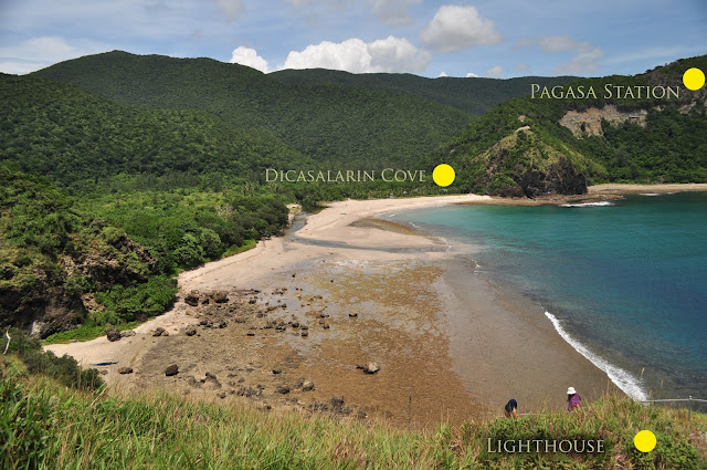
A few more steps back our track is a left cut marked by a keeper's station where we were asked to register for a trek down to the Dicasalarin Cove. At that spot, in fact, we can already take good pictures of the entire cove. Just because of the obsession of a friend, which I kind of shared eventually, we single-mindedly headed towards the cove to discover what that unpopular white figurine looks like sitting very discreetly at the tip of the cove. What we thought was an easy 20-minute descent turned out to be almost a tiring hour walk under the midday sun. It looked near because the cove was in sight. We missed the curbs and turns in our calculation consequentially sacrificing our female companion whose tolerance to this difficulty we may have unintentionally discounted in the process.
 |
| Dicasalarin Cove |
 |
| (Left) Exit from the forest and entrance to the (right) beach front |
 |
| Walk from the curb to the lighthouse on the hill. |
Finally -- the cove.
Much like the description of a good source from the internet, we had to walk through a forest of tall trees to reach the grandeur of the beach front. White sands stretched to a smile and dimpled with a rocky hill at the end. I knew that our ultimate goal was the thrill of a "eureka" moment to finally behold that white obelisk-like structure which form by now looked more pronounced. After several refreshing gulps of water from their fountain (sourced from an uphill river exiting to the beach), we walked our way to the tip of the cove and climbed a total of approximately 200 steps up the rocky hill to see the work-of-art unfolding before us. It was after all, a strangely designed, lighthouse ---- and nothing else. We took shade in the opening of the tower base. Our female companion sought solace by taking a short nap while the cold sea breeze fanned her to sleep. My other friend's consolation was taking pictures. I climbed up the lighthouse to model a few shots. :)
 |
| The cause of blistered soles and burnt skin, The Dicasalarin Lighthouse. |
 |
| Photos courtesy of baktincorporation. |
 |
| Where the river meets the sea. |
The ordeal, the misadventures, the simple things made extraordinary by experience, memorable as they were bring so much joy now that I think back. But wait....that's how I wanted to keep it mind. I am still trying to forget that we had to redo the climb and walk under the scorching sun up through the turns, the curbs, and yet to another descent to go back to where the walking started. Let my friend's blisters on her sole take you further into details.. ;) Enjoy!!!
 |
| Mapping the return trek from the Lighthouse to the Cove, through the forest, and back to the PAGASA Station. |
 |
| Artists' Village tucked quietly in the forest leading to the cove. Architecture by Jose Danilo Silvestre |
 |
| Resting on hardwood furniture in the Artists' Village. |
More of the Baler series to follow.
Read the complete Baler Series:
1. Haller (Hello) Baler!
2. Baler Series: The Rolling Stores
3. Baler Series: At Last, Eureka!
4. Baler Series: Historical
5. Adventures
View Larger Map


You're on a roll! :)
ReplyDeleteEy, just trying to clear out a bunch of pending to dos -- "pag may time". :D
DeleteGnhn kaau ko sa Dicasalarin Cove.
ReplyDeleteLovely photos, Mike.
Tnx Bee. Glad you liked them. Coves remind me of Zambales.
DeleteCoves will never be the same to us. lol
Deletehahaha.
DeleteAng di gyud nako malimtan...kay si Mike naghike in the dark!
Deletehaaay. . khonie.. i cringe everytime I remember moments like that.. especially that. i was never more afraid of the dark than that time. todamax na akong ampo atong panahuna.. hahaha
Delete